Skip to content
Ranger Tug Kismet Anchored, Hurricane Harbor, Florida

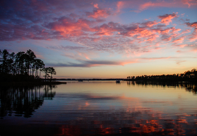
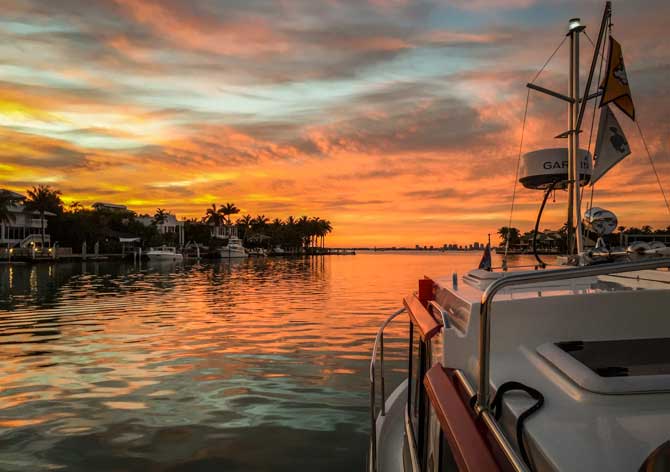
Sky On Fire – Hurricane Harbor – Key Biscayne, Florida

Hurricane Harbor Provided Us with an Idyllic Sunset! Leaving Miami in our wake, we pointed our bow toward Key Biscayne Island. Jim did some research and found this beautiful anchorage, a spot further enhanced by a flaming sunset. The sky was on fire, I must have taken a hundred photos as it morphed with varying shades of sky blues, oranges, and hot red tones. Soon after we threw the hook into the harbor, we had a visit by local law enforcement. Hurricane Harbor is adjacent to a popular boater's weekend hang out, located just outside the entrance to the harbor, consequently, there…

Read more
Kismet is Hooking her Way to Fort Lauderdale

Hooking Our Way to Fort Lauderdale

Exploring New Inlets While "Hooking" Our Way to Fort Lauderdale! It's a very rewarding experience, for us, when we have an opportunity to explore new inlets, coves, and potential anchorages while cruising AND we end up throwing the hook for the night. The previous times we’ve cruised north or south between Stuart and Fort Lauderdale we’ve always traveled past Peck Lake, Lake Worth, Lake Boca Raton, and Lake Sylvia without ever stopping let alone anchoring. We’ve either been in too much of a hurry to get somewhere else or didn’t have the time, all that is different this trip south on the East Coast ICW.…

Read more
Sunset, South Bay Cove,, Lake Okechobee

Rim Route to South Bay Cove on Lake Okeechobee, Florida

"Big Water" – Lake Okeechobee and the Rim Route From our one-night stop in LaBelle, we proceeded toward Lake Okeechobee (or in Seminole Indian language, Big Water), we'll be taking the rim route around the lake instead of going straight across this time. The Okeechobee Waterway, which includes the Caloosahatchee River and the St. Lucie River, boasts 134.3 nautical miles from west to east and is the 2nd largest freshwater lake in the United States. You can transit the lake by going straight across or by the more protected, though shallower, rim route that follows the southern edge of the lake. We've…

Read more

Pristine Anchorage at Mullet Key – Fort DeSoto State Park, FL

Two Fortresses Were built to Guard Against Invasions that Never Came, Mullet Key is one of them As one leaves the Gulf of Mexico to enter Tampa Bay, Mother Nature provides two keys that stand sentinel at the entrance of Tampa Bay. In 1889, Mullet Key, to the north, and Egmont Key, to the south, had fortresses built to guard against invasions that never came, remnants of both forts remain today in the parks that were created in the late 1800s. Robert E Lee made the recommendation, in 1849, that both Mullet and Egmont keys become fortified. Fort DeSoto, on Mullet Key, was built in 1889…

Read more

Peaceful Night on the Hook – Redington Beach, Florida

Redington Beach Provides a Well-protected Anchorage for the Crew of Kismet. Redington Beach is located in Pinellas County, west of Tampa on a barrier island in the Gulf of Mexico, the town is only one-mile square and has four parks, five public beach accesses, and a causeway with benches for relaxing and fishing. We've stopped here before, it makes a good spot to anchor when traveling north or south on the ICW. The dolphins were loving our boat action today, they love to swim just under Kismet's wake. The anchorage is lined with small homes to one side, a park in the middle, some condos, and several restaurants.…

Read more
Sunset, Ingram Bayou

Ingram Bayou – “I’m Going Back Someday, Come What May, To Blue Bayou”

After a smooth cruise through Mobile Bay, from Eastern Shore Marina, we made a port-side turn into the protected Intra-Coastal Waterway where we soon passed our first tug and tow (above). The first landmark we see on the ICW is Lulu's Cafe (below). Not stopping there this time though as we were both in a hurry to get settled into our night's anchorage. Returning to Ingram Bayou... Ingram Bayou is one of our favorite anchorages, this will be our third time stopping here. The afternoon was spent by first hanging by some scarves to block the heat of the sun while we settled into lounge on the…

Read more
Anchorage at Fox Island, North Channel, Canada

Fox Island – North Channel, Canada

Fox Island Provided a Beautiful Rocky Hiking Trail Lined with Berries When we left South Benjamin Island we headed for Fox Island, located only about four miles from South Benjamin. We had anchored here once before with our Silverton and remembered how beautiful it was. The landscape is rocky all around the anchorage's perimeter, offering good hiking and photo opportunities. When we anchored here previously, we were the only boat on the hook in the channel, this time there were several boats already at anchor. Our boat has a very shallow draft, about 2.5 feet, so we can usually get…

Read more
Ranger Tug Kismet, Sailboat, Eagle Island, Canada

First Anchorage – Eagle Island

After launching the boat in Spanish, we decided to anchor at Eagle Island. There we spent most of the late afternoon and early evening organizing and storing stuff on the boat. Since Jim organized the rendezvous, we have boxes and boxes of ditty bag items, printed agendas and books to stow on board. We finally found a home for everything and were able to relax on the back deck to enjoy the last remnants of the sun setting behind the island. Eagle Island, which is 2.25 miles in length, has a large open bay, but we found it to have good protection…

Read more
Ranger Tug Kismet Anchored, Bainbridge Island

Eagle Harbor Anchorage – Bainbridge Island, WA

Bainbridge Island sits north and west of downtown Seattle – the Eagle Harbor anchorage was our choice for one night on the hook. On a clear day, you can plainly see Seattle’s skyline from the Eagle Harbor Anchorage, eight miles to the east across Puget Sound. The city of Bainbridge Island is home to Eagle Harbor, which can be a little confusing. Kind of like New York, New York but in this case it’s Bainbridge Island, Bainbridge Island! Eagle Harbor juts in from the east shore of Bainbridge Island opposite Elliott Bay. It is two miles long and affords excellent anchorage in 30 to…

Read more
Spencer's Spit Anchorage

Spencer Spit – Last Stop in the San Juans

What’s nice about Spencer Spit is that one can choose which side of the spit to anchor or catch a mooring ball on. Spencer Spit, situated on the eastern side of Lopez Island in the San Juan Island chain, is a Washington State Marine Park, which means the area has mooring buoys, beach campsites, and hiking. We’ve never anchored or moored here, so we choose this spot as our days' end destination after we departed our yacht club friends at Garrison Bay. What’s nice about Spencer Spit is that one can choose which side of the spit to anchor or…

Read more

Into the Light… Jedediah Island

Thankful for the Shelter and Beauty of Jedediah Island! The closer we got to Jedediah Island the calmer the waters and our nerves became. As we sliced through the channel, with the powerful push of following seas behind us, we traveled between Jedediah and Bull Islands (both islands are protected by two larger islands, Texada and Lasqueti), making our way to the leeward side of all the turbulence in the straits. Almost magically the wave activity became a non-issue. We immediately found a pint-sized, well-protected, cove suitable to drop anchor, a boat was just leaving so we hovered out a…

Read more
Rock Formations, Hardy island, Canada

Positioning Ourselves at Hardy Island for the Run Up to Chatterbox Falls

The Anchorage at Hardy Island is Located at the Base of Jervis Inlet We were somewhat protected by Texada Island as we cruised 21 miles southeast from Powell River to Hardy Island. The anchorage at Hardy Island is located at the base of Jervis Inlet. We are positioning ourselves for the cruise up to Princess Louisa Inlet, Malibu Rapids, and finally Chatterbox Falls. Entering Blind Bay we found calm waters ideal for anchoring in a narrow, well-protected, cove within Hardy Island Marine Park. As we were scouting for a spot to drop our hook we came across a small black bear…

Read more
Squirrel Cove Town Dock, Desolation Sound

Fighting Rapids at Squirrel Cove – Desolation Sound, British Columbia

We left Pendrell Sound this morning to motor over to Squirrel Cove. Several boaters recommended this spot as a very well-protected anchorage and since our weather turned a little sour we decided the cove might just be the ticket for a good night's sleep. The photo below not only shows a pretty typical type of cruising boat in Canada's Desolation Sound but some of the huge logs boaters have to contend with when cruising this area. Squirrel Cove is a popular anchorage for cruisers! The cove provides a very protected anchorage for a large number of boats and, as a…

Read more
Kismet Anchored, Laura Cove, Desolation Sound

Lots Of Rocks In Laura Cove

Laura Cove Reminded Us of Cruising Ground Closer to Home, the North Channel, Ontario, Canada. During our three days in Laura Cove, we swam next to the boat every day in the clear, warm water. We hiked a little, and took dinghy rides around Prideaux Haven to explore and visit with other boaters we knew who were also staying in one of the coves for the Canadian holiday weekend. We liked our spot. There were three other boats rafted off the narrower tip of the rock and a few more on the other side but there wasn't any room for another boat to…

Read more
Tenedos Bay Anchorage

Tenedos Bay Anchorage – Desolation Sound

From Refuge Cove it was a short 7 to 8-mile hop over to Tenedos Bay. Once in the midst of Desolation Sound every port, cove, or bay is no more than a day's cruise from your starting point. This close proximity between points of interest allowed us to take our time, linger longer, leave later, and cruise slowly while still arriving early to any spot on our scheduled route. Tenedos Bay provided a tree-lined canyon and a well-protected spot just a short dinghy ride to the trail that leads up to Unwin Lake. Our chosen anchorage provided a tree-lined canyon…

Read more
Freshwater Lake, TeaKerne Arm, Desolation Sound

Teakerne Arm – A Waterfall And Fresh Water Lake

Teakerne Arm – A Waterfall and Hike to a Fresh Water Lake Leaving Grace Harbour, we had a short cruise to Lewis Channel before we made a turn up into Teakerne Arm and another anchorage in the British Columbia wilderness. In the open waters I kept seeing a distinctive peak off in the distance, it seemed to appear from behind and above the waterside hills, fjords, and mountains as if it was following us as we worked our way around Desolation Sound. With a little research, I found Mount Denman (the pointy-tipped mountain in the middle of the photo below -…

Read more

McKernan Creek Anchor Before Joe Wheeler State Park

We like anchoring in McKernan Creek! After leaving Grand Harbor Marina, we made two anchorage stops before we got to Joe Wheeler State Park. The first, Little Bear Creek (above and below), was a new spot for us while our stay at McKernan Creek was our third time at anchor there. Both anchorages met with our satisfaction and provided a colorful and comfortable night on the hook. On the move again early the next morning we passed the bridge at Florence, Alabama (below). To get to McKernan Creek we had to lock through the Wilson Lock and Dam. At 110…

Read more
Tennessee River

Blue Creek Anchorage By Cuba Landing Marina

Blue Creek anchorage is just past Cuba Landing Marina. Leaving Pebble Isle Marina we had our sights set on an anchorage we'd never been to before. Twenty miles upriver at MM116 of the Tennessee River is Blue Creek, Cuba Landing Marina is located there. (The photo above, and below, shows the entrance to the marina and the cove we anchored in.) Having just left a marina we inched our way past Cuba Landing to a shallow, relatively open cove. We found a few more boats anchored there for the night in 5 to 8 feet of water. We've never anchored…

Read more
Kismet in Fog, Cypress Creek, Tennessee River

Cypress Creek Anchorage – Tennessee River

We left Duncan Bay knowing we'd travel south on the Tennessee River for only 4 hours, so it wasn't going to be a long day. Twenty-nine miles later, at mile marker 62.6, we made a starboard turn into Cypress Creek, then another right into the first cove. What we found was an anchorage that provided us with calm waters in very protective, natural surroundings. Because of our short cruise day, I took advantage of the calm water by continuing my work on the dinghy davit bracket installation (see next post). I like to maximize my downtime by having a few…

Read more
Produce on Kismet

Landing in Duncan Bay – Tennessee River

Duncan Bay was our choice for a peaceful night on the hook! Our three-week goal was to travel 250 miles on the Tennessee River while meeting Loopers on their southern migration and concluding our trip after attending an AGLCA Rendezvous at Joe Wheeler State Park Marina in Rogersville, Alabama. With three weeks to enjoy this famous heartland river, it felt good knowing we could really take our time leaving a spot late in the morning or deciding to stop early in the day to relax and familiarize ourselves with a new anchorage. With that said, we left Green Turtle Marina,…

Read more
Ranger Tugs Kismet, Mary Ann Cove, North Channel

First Time in Marianne Cove

Lots of Room in Marianne Cove Tonight! On our way up Baie Fine, we saw this marker on shore (above). It's a marking for the red buoy – the channel through this area is so narrow they had to mark it on the rock instead of a red buoy. On this day we chose to try a new anchorage (new to us) at Marianne Cove. We've anchored at the Pool (located at the furthest end of Baie Fine) before and enjoyed that area, but we've heard so much about how well-protected and beautiful Marianne Cove is, we decided to stop short of the Pool and…

Read more
Kismet Anchored in Colins Inlet, Georgian Bay

Keyhole Island – A Little Peek Into the Northwest Side of Georgian Bay

Keyhole Island on the Northwest Side of Georgian Bay. Georgian Bay is on our cruising bucket list, a trip like this deserves a dedicated stretch of time to explore properly. With that said, we decided to get our toes just a little wet. After we left Covered Portage Cove, we passed through the channel in Killarney for a short, one-day, cruise and anchor in the northwest side of Georgian Bay. Four miles or so east of Killarney is the western entrance to Collins Inlet and a 10-mile run to Mill Lake. It was Collins Inlet, a narrow channel, where we spent…

Read more
Kismet Anchored, Covered Portage Cove, North Channel

Covered Portage Cove – The Perfect Anchorage

Covered Portage Cove anchorage – High rocky cliffs and near-perfect protection from the elements. From South Benjamin Island we made our way past Little Current, Strawberry, and Heywood Islands as we skirted south of Frazier Bay to enter Lansdowne Channel on the way to Covered Portage Cove, just west of Killarney, the old provincial outpost that separates Ontario's North Channel from Georgian Bay. We had only dinghied to Covered Portage Cove anchorage in 2007 when we had docked our boat for a few days in Killarney. We vowed then to put it on our list as a future anchorage spot. When I…

Read more
Kismet Anchored, South Benjamin Island, North Channel

South Benjamin Island – View From The Top

South Benjamin Island, a Rocky Delight! Topping off our great anchorage find is the incredible view from the top of this South Benjamin Island. This is where Jim found all those yummy blueberries and where we went to stretch our legs and enjoy the view when we felt cramped on the boat. Great weather during our stay here, hot temps with unseasonably warm water for swimming. Life is good for the crew of Kismet tied up to this little South Benjamin Island. We took a long hike on the island that sits in front of the Benjamin's, it protects the…

Read more
Victor with bag of Wild Blueberries on Dinghy

South Benjamin – Where’s the Beauty?

South Benjamin – It is often said that beauty is in the eye of the beholder! I reference this because we recently spent time at the Benjamins, South Benjamin specifically, and it is our contention that the rocks on this island are gorgeous, Not to mention the blue beauties Jim found on those rocks. We recently cruised Lake Powell, in Utah/Arizona, the landscape there is ALL rock and water. Both are beautiful, however, the difference between the two locations is dramatic. Lake Powell has very large, rock buttes, plateaus, and mountains, and not much greenery except for Navaho Mountain, whereas…

Read more
Back To Top